Thanks to coronavirus, our streets are about to look a lot different as we try to physically distance and get back to normal at the same time.
Walking down the street in our towns and cities is difficult enough at the best of times, thanks to narrow roads and narrower pavements.
But while it’s fine to heed the exhortations to get out and get some exercise, there’s a problem. Where are we actually allowed to wander? What looks like an open street, square or walkway often isn’t.
I was reminded of an old-ish article in the Guardian, which linked to this bit of research on London’s privately-owned public spaces. I commented at the time (remember? No?) that it would be good to see a similar project in Leeds. Alas there isn’t one; but next time you’re wandering around Leeds Dock you might want to think about whose land you’re being graciously allowed to exercise on.
When I worked over that way there was a popular walking route taken by office workers along the bank of the river. Follow this link to Google Maps; the route is the green line south of the river between Crown Point Bridge and the footbridge on the left. If you look at the user-generated photos you’ll notice a metal fence with lockable gates at either end. Not a health & safety thing as residents of the flats can still get down their through another gate with a keypad.
Streets apart
Now: okay, you could argue that the land was previously not a through route and the developer has the right to limit access how and when they please. But what about places that were once streets?
While walking home from my weekly shop it’s obvious that many of the usual cut-throughs people take are now closed off completely. Take Victoria Quarter. A little over 30 years ago Queen Victoria Street was an open street between two buildings; County Arcade and Cross Arcade were also open. Now they are part of Victoria Quarter they are closed. The shops inside are all closed anyway, so why are the walking routes not open? When did we sell off these public areas?
Trinity Street was paved over long ago, as were the Trinity and Burton Arcades to form shopping areas. Now they’re gated off as part of Trinity Leeds.
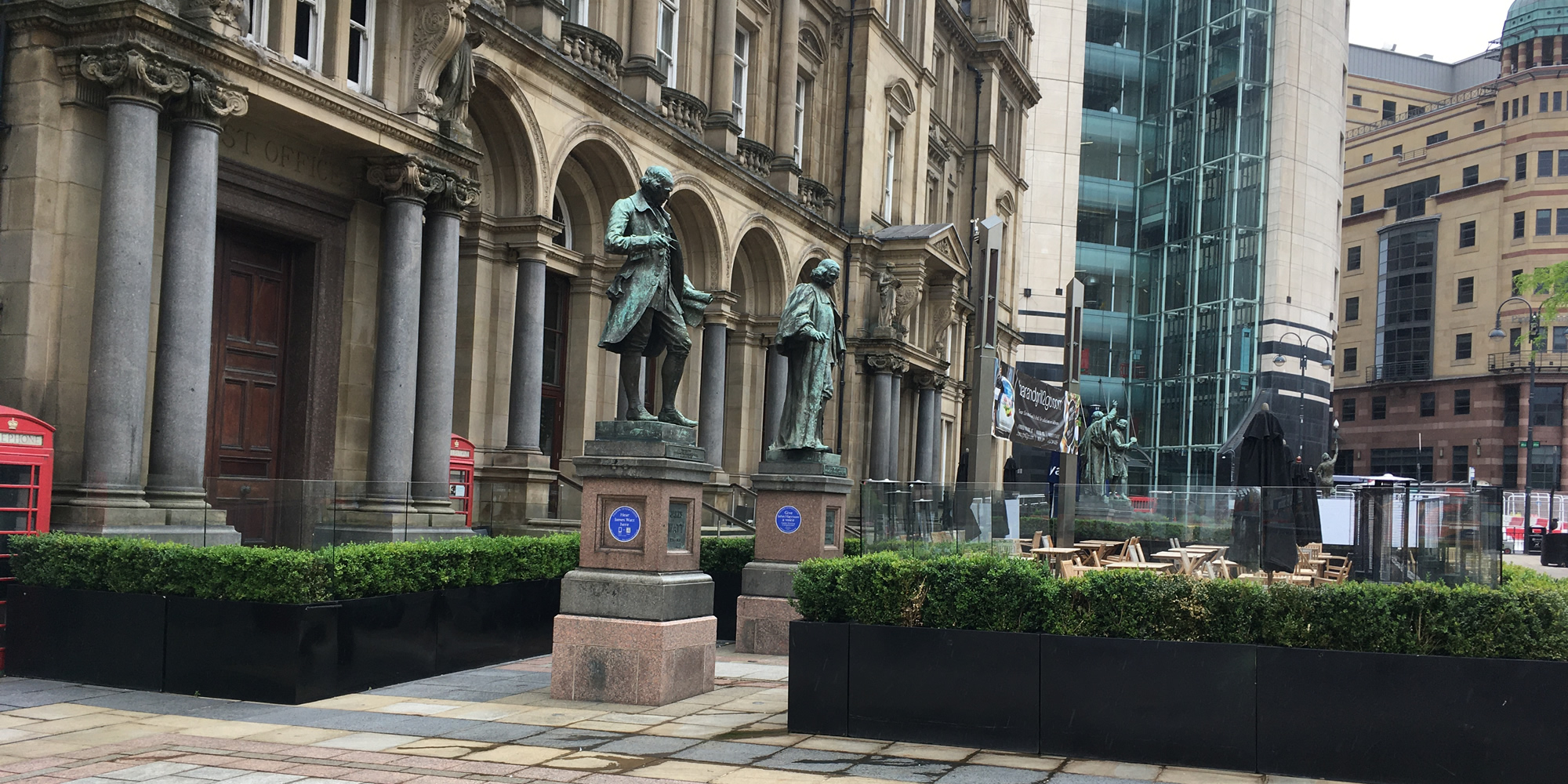
My favourite example though is City Square – see the photo at the top. It was constructed at the end of the 19th century as a public space. In the late 1990s the roadway in front of the Post Office (the building in the photo) was closed off, the whole area being repaved a few years after that. Then the Post Office was closed and the building rented out to two restaurants.
The area cordoned off by the fake hedges and Perspex screens… that used to be pavement and road. The public highway. Now, as every year, it’s cordoned off. In theory it’s still public space but the public can’t pass through it they have to walk round it, into the area that used to be fountains, until they stopped working. Convenient 1.
And this is the problem with the ‘new normal’. In order to make space for pavement cafes and outside dining any reasonably passing pedestrians will have to move closer together, even on the wider pedestrian streets. Leeds has several pedestrianised streets, immediately made narrower as (mostly) chain restaurants moved in.
Tough choice. But I think we can guess which way things will go, certainly over the summer. After that… who knows?
Postscript
The Guardian published a picture story of research into the widths of pavements in various UK cities, including Leeds. It didn’t include Briggate. Okay, that’s fully pedestrianised, but it included City Square which also has no pavements. It also included part of Wellington Road, which now forms part of the car park in the middle of Armley Gyratory. Compare their map in the link above with the version in this story. They’ve also included the Inner Ring Road and the M621. Good luck walking along those.
- A joke; there used to be public toilets underneath City Square (a convenience).[↩]